


Description
What our All about Asia lesson plan includes
Lesson Objectives and Overview: All about Asia explores the history and cultures of the countries of this amazing continent. Students will learn interesting facts about several countries and learn where Asia is on a map. They will also discover some of the famous landmarks throughout the continent. This lesson is for students in 4th grade, 5th grade, and 6th grade.
Classroom Procedure
Every lesson plan provides you with a classroom procedure page that outlines a step-by-step guide to follow. You do not have to follow the guide exactly. The guide helps you organize the lesson and details when to hand out worksheets. It also lists information in the yellow box that you might find useful. You will find the lesson objectives, state standards, and number of class sessions the lesson should take to complete in this area. In addition, it describes the supplies you will need as well as what and how you need to prepare beforehand. Students will need colored pencils for the activity, as well as internet access.
Options for Lesson
You will find several additional ideas and activities to incorporate into the lesson in the “Options for Lesson” section of the classroom procedure page. Students may work alone or in groups for the activity. For the activity, distribute larger paper that students can use to draw a map of Asia and identify its countries. Assign one or two countries to each student to research and later present to the class. Students could research the various landforms and other attractions and present the information they find to the class. Invite a person to speak with the class who may have visited one or more Asian countries. Plan an “Asia Day” where students can bring Asian foods. Locate a school in Asia with which students can write to pen pals.
Teacher Notes
The teacher notes page provides an extra paragraph of information to help guide the lesson and remind you what to focus on. It suggests you show one or more videos that supplement your instruction. The blank lines on this page are available for you to write out thoughts and ideas you have as you prepare the lesson.
ALL ABOUT ASIA LESSON PLAN CONTENT PAGES
Introduction to Asia
The All about Asia lesson plan includes four pages of content. Asia is the largest of the continents. In fact, it covers about 30% of all the earth’s land area. It is so large that we separate it into six regions: Northern, Central, Eastern, Western, Southern, and Southeast Asia. Asia is almost entirely in the northern and eastern hemispheres of Earth. As the largest of the seven continents, it covers over 17 million square miles. For comparison, Asia is almost two times the size of North America.
Two of the most populated countries in the world—China and India—help add to Asia’s population of over 4 billion people. That equates to approximately 60% of the world’s population! In other words, 6 out of every 10 people in the world live in Asia.
The continent borders the Ural Mountains to the east, the Arctic Ocean to the north, the Pacific Ocean to the west, and Indian Ocean to the south. It is also home to the highest point on Earth, Mount Everest (29,029 feet). Mount Everest is in the Tibetan region of the Himalayan Mountains. The lowest point on land also exists in Asia—the Dead Sea (1,410 feet below sea level).
The longest river in Asia is the Yangtze River (3,915 miles). It is the third-largest river in the world, but the longest in the world flowing through a single country—China. The Caspian Sea is the biggest lake, as well as one of the deepest with a depth of 3,300 feet. Five countries share the coastline of the sea. Finally, the driest place is the Gobi Desert ̧ the fifth-largest desert in the world. It is actually a cold desert that mostly covers north and northwest China and southern Mongolia.
Geography and Climate
Because of the large size, Asia is a diverse country, rich in its races cultures, and languages. In addition, many of the world’s major religions originated in Asia. This includes Christianity, Judaism, Islam, Hinduism, and Buddhism. The continent’s size yields geographic diversity as well. Asia includes eight different climate types: deciduous forest, coniferous forest, alpine/mountain, rainforest, desert, tundra, grassland, and savanna.
Deciduous forests experience all four seasonal changes. They have warm summers and cold, wet winters. Coniferous forests, on the other hand, really only have two seasons. They have cold and dry, snowy winters and warm summers. The alpine or mountainous areas are windy and snowy. Temperatures during the winter months can reach below freezing and only reach the 50s (°F) in summertime.
Rainforests have high temperatures and lots of rainfall throughout the whole year. The desert regions, on the other hand, receive very little rainfall year around. They experience warm to high temperatures throughout the year. In the tundras, a layer of permafrost (frozen soil) covers the land. The areas have winters and summers, neither of which yield much rain.
Grasslands get an above average amount of rainfall. The summers are hot and the winters are cold. Finally, there are the savannas. These regions also experience very high temperatures throughout the year. It rains, but only during the summer months. The desert, mountain, and tundra regions are the least populated, and most people live in Eastern, Southern, and Southeast Asia.
Resources and Animals of Asia
China, India, and Japan are the most economically developed countries. Throughout Asia, the living conditions have improved. However, there are many pockets of poverty with a growing gap between the rich and the poor. This is despite several large oil-producing nations in Asia—Iran, Iraq, Saudi Arabia, Kuwait, and the United Arab Emirates.
In all, there are 48 countries, which includes two countries that are also a part of Europe—Russia and Turkey. In addition, there are some countries that United Nations does not recognize as official countries. Those countries may be technically part of another country, such as Taiwan, a part of China. However, Taiwan recognizes itself as a separate country.
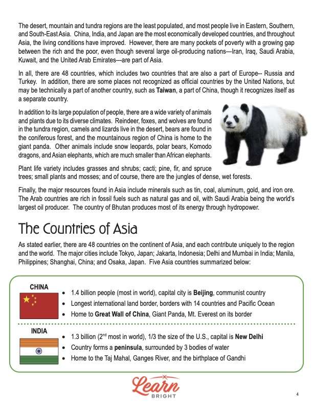
In addition to its large population of people, there is a wide variety of animals and plants due to its diverse climates. Reindeer, foxes, and wolves live in the tundra region. You can find camels and lizards in the desert. Bears are found in the coniferous forest, and the mountainous region of China is home to the giant panda. Other animals include snow leopards, polar bears, Komodo dragons, and Asian elephants, which are much smaller than African elephants.
Plant life varieties include grasses and shrubs; cacti; pine, fir, and spruce trees; and small plants and mosses. And of course, there are the jungles of dense, wet forests. The major resources in Asia include minerals like tin, coal, aluminum, gold, and iron ore. The Arab countries are rich in fossil fuels like natural gas and oil. In fact, Saudi Arabia being the world’s largest oil producer. And the country of Bhutan produces most of its energy through hydropower.
Countries and Attractions
As stated earlier, 48 countries compose the continent of Asia, and each contribute uniquely to the region and the world. The lesson provides a few points of information for five of Asia’s countries: China, India, Japan, Vietnam, and Qatar. China, for instance, is the largest country in the world in terms of population. India is the second-most populous and is home to the Taj Mahal.
Japan’s capitol is Tokyo, and forests actually cover 73% of the country. Vietnam borders China to the north and the South China Sea to the east. It is well known for its beaches. Qatar only has 2.7 million people. It is only as large as the state of Connecticut. Qatar is a desert country, so only 5% is useful for farming.
Not surprisingly, Asia is home to many attractions and landmarks because of its size. To see them all, a person could spend a lifetime visiting each country. The Forbidden City in Beijing was the Chinese imperial palace between 1420 and 1912. The Great Buddha of Kamakura is in Japan. It sits on the grounds of a Buddhist temple and is nearly 44 feet tall.
Tehran, Iran, is home to the Freedom Tower, or Azadi Tower. Built in 1971, it is a curious and unique structure that includes both modern and ancient architectural styles. And of course, there’s Mount Everest in the Himalayas. Its peak is just over 29,000 feet high. It borders both Tibet and Nepal. Many refer to the mountain as the “Mother Goddess of the Sky.”
ALL ABOUT ASIA LESSON PLAN WORKSHEETS
The All about Asia lesson plan includes three worksheets: an activity worksheet, a practice worksheet, and a homework assignment. Each one will help students solidify their grasp of the material they learned throughout the lesson. You can refer to the classroom procedure guidelines to know when to hand out each worksheet.
TIC TAC TOE COUNTRIES ACTIVITY WORKSHEET
For the activity, students will work with a partner and play tic tac toe. There are two “boards” with information about various Asian countries. Each player will take turns matching the country “pieces” to the facts that they represent. Students must cut out the country cards and shuffle them first. Then they will take turns picking a card and placing it on the board where there is a matching fact.
INTERESTING FACT SEARCH PRACTICE WORKSHEET
As with the activity, students will work with a partner for the practice. They will choose two countries from the list on the page and find an interesting fact about each one. Then they will create a slideshow about the countries to present to the class.
ALL ABOUT ASIA HOMEWORK ASSIGNMENT
The homework assignment requires students to demonstrate what they learned by answering a series of prompts and questions. After they answer the questions, they will write where they found the answer next to their responses.
Worksheet Answer Keys
The All about Asia lesson plan includes answer keys for the practice and homework worksheets. All the correct answers are in red to make it easy to compare them to your students’ responses. If you choose to administer the lesson pages to your students via PDF, you will need to save a new file that omits these pages. Otherwise, you can simply print out the applicable pages and keep these as reference for yourself when grading assignments.